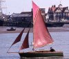
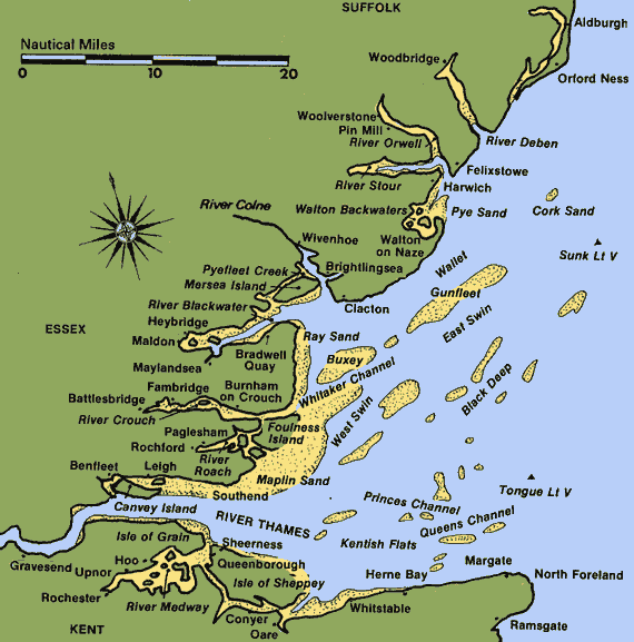
As you sail down the historic trade route that is the River Thames, it suddenly widens out into a great triangular estuary. After seemingly endless marshes, the southern shore rises to give low cliffs with marshy gaps running due east for another thirty miles to the cliffs of the North Foreland with its’ lighthouse. The low sea walls of the Essex shore quickly fade from sight, running another fortyfive miles northeast to the low shingle headland of Ordfordness and our only other lighthouse. If you imagine a line running seventeen miles from Essex to the furtherest drying bank, the Kentish knock, and on a similar distance to Kent, it would enclose some five hundred square miles of superb sailing water with twelve rivers totalling about one hundred and twentyfive miles of sheltered sailing for those days when Father Neptune turns spiteful. It is difficult to think of any better area in which to keep and sail a small boat. A one hundred mile trip from my mooring at Maldon on the river Blackwater can take me anywhere from Orforness to the North Foreland which I regard as my ‘Pillars of Hercules’. Beyond them, the tides run harder, the seas mount up quickly with a rising wind, and there is a dearth of safe, easily entered harbours for refuge.
The outer estuary is littered with sand banks, most of which appear at low water and have been marked with a fascinating collection of posts and beacons over the years together with gun towers left over from the war. At one time there were three lighthouses on piles built out on the sands. All are long since disused. Only the Gunfleet Tower remains and is now covered with signal masts, presumably transmitting weather reports.
Rounding Islands always gives a sense of satisfaction and achievement to a voyage. The Thames Estuary has islands galore. The largest is the Isle of Sheppey, which is something of an achievement to round on a weekend trip from my blackwater S.C at Heybridge. In Roman times it was possible to round the Isles of Grain and Thanet but they have long been joined to the mainland by silting and dam building for road access. The River Crouch has three mile long, flooded Bridgemarsh Island and between it and the Thames is an archipelago of Wallasea, Foulness, Potton, Rushley and now joined up Havengore and New England Islands. The River Blackwater has Northey and inhabited Osea island close to Maldon and roundable in an afternoon sail from my mooring but remember that both have an half tide causeway for vehicular access at low tide. Nearer the River mouth is Pewit Island which shelters the moored yachts in Bradwell Creek on the south side and on the northern side is the four mile long Mersea island with its’ causeway that only floods at spring tides. It is not normally roundable as the causeway is fenced either side, and the gaps on either side are some hundred yards apart. This provides the perfect site for a Round the Island dinghy race with hordes of helpers carrying the craft over the road while the police hold back the traffic. To add to the confusion, craft may round the island in either direction.
For those sailors with a ‘Greta Garbo’ complex, which includes myself, the Thames Estuary abounds in quiet isolated places but a shallow draft boat is essential for most of them. The deep pool between Potton Island and Foulness just off the River Roach is one exception. My favourite is the little creek off St. Peters chapel at Bradwell. It is only usable with a westerly wind and dries an hour and a half after high water but I have never been joined by another craft in forty years. Once dry, there are miles of marshes to roam over and plenty of wood for a fire. Further south are lonely outfalls in which you could lay dead unfound for the rest of your life! The handiest spot for my mooring is just inside Lawling Creek on the western side. As there is a strong eddy on the flood behind the shingle point with its’ crown of scrub, the tide always flows in the same direction and the mud is flat and soft. The most remote but most delightful is ‘Little Japan’ on the upper Alde where a sandy beach runs up to a low sandy cliff crowned with scots pines. When I entered Cliff Creek off the western side of the Lower Hope, the only other chap there, who was busy fitting out a large old yacht, said that I was his third visitor in two years. He added that he had worn out three old vans reaching the site along the mule track from civilization. The River Medway has hiding holes galore. Perhaps the best is off the southern side of the Shalfleet where it opens onto half-Acre Creek. The marshes there seem to go on forever.
An endlessly varying fleet of craft has traded to every corner of this area since before Roman times. Every town and hamlet had its’ own quay, dock, hythe or jetty. Farms in the area soared in value if the had access to salt water. All manner of craft have used these trade routes but Thames spritsail barges evolved as the queens of them all and some thirty or forty of them have been preserved. Thus you can still occasionally see a lofty mast way inland behind the sea wall. Find the old dock or jetty and look for a green overgrown green lane leading to the local farm buildings. Some have fallen to the bulldozer but many remain. I have spent many leisure hours seeking them out over the last fifty years. Most are pretty decrepit now but one at least remains as solid as ever for it was built in 1832 from stones from old London bridge. This is Beaumont Quay in the heart of the Secret Water of dream breeders, Swallows and Amazons.