Of course it was so much easier for the Romans. In their day a wide tidal estuary reached inland almost to modern Canterbury with a handy northern arm that joined the Thames estuary between Reculvers and Margate and saved generations of Roman sailors the long and dangerous haul round the North Foreland. When Hengist, the first of the Saxon invaders, landed here at Ebbsfleet in 449AD the estuary was dominated by the Roman castle of Rutupiae, built on rising ground on the southern shore, but the Romans were gone and the harbour at the foot of the mighty walls was already silting up. Trade moved downstream to Sandwich which thrived for nearly a thousand years on an ever-shallower and more winding river as the sand and mud encroached year by year. In the first World War the need to move vast quantities of men and munitions to France led to the building of the long jetty at Richborough, two miles further down and it came into use again for D-Day. Today, the many yachtsmen calling at Ramsgate en route to and from the Continent never give a thought to the river Stour, once the principal commercial highway to the hinterland of North Kent.
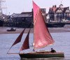
When ‘Shoal Waters’ arrived off Pegwell Bay one evening in August the centreboard whispered regularly as we passed the miles of sand dunes that reach out north of Deal and we were glad of the tall cooling towers of the power station, standing out bold against the hazy sunset, to help us find the entrance. The channel is well marked these days for the last half-mile and a few minutes later the anchor went down, the riding light went up and the crew got down to some serious sleeping after a fine passage from the Isle of Wight. The sandy mudflats on either hand looked warm and friendly after the cold, hostile cliffs and difficult harbours we had encountered along the south coast. ‘Shoal Waters’ is essentially a creature of the marshes and shallow places for she only draws 10 in with the plate up. We – skipper and 16-year-old son – planned to explore the old trade route to Fordwich, the old port of Canterbury, whither all the stone for the Cathedral was taken from Caen in Normandy. All manner of produce once passed this way including forty-thousand-herrings-a-year, paid by the Citizens of Sandwich as rent to Christ Church. We noted the swift tidal stream that would help us on our way tomorrow, bade goodnight to tile seabirds scurrying over the fast covering mudflats and turned in.
Next morning was heavy with mist as ‘Shoal Waters’ got under way with the last of the flood and a wind from the north. The river can best be described as a series of donkey’s-hind-legs forming a loop some two miles long with Sandwich at the southern end, skirting Richborough castle (as the ruins of Rutupiae are now known) and coming back to the western edge of the power station. At the narrowest point of the loop is the sonar sluice, which presumably allows flood water to bypass Sandwich altogether after periods of heavy rain. A red flag (red lamp at night) is shown when the sluice is open to give dire warning for small craft but it has always looked quiet enough whenever ‘Shoal Waters’ has passed it. Industry is moving into this area now and a marina with moorings built out into the tideway has been established since our first visit in 1965 when yachts were few and far between.
The marshes gave way to the old buildings and wharves of Sandwich with its ancient swing bridge and Barbican trembling under the roar of modern industrial traffic. We lowered down and swept on with the stream past the old warehouses, quaint names of long-dead companies still discernable on faded signs, towards a line of elm trees on a ridge where grey ruins peep over the reeds, all that is left of the proud Roman fortress. Now we had to beat but the stream helped us along in fine style. There seems to be only about three or four hours flood and a long ebb, depending on the quantity of rain water coming down, for the river Stour drains a wide area of North Kent. The water level rises sharply while the stream is still running seaward, after the manner of the Bure at Yarmouth. Indeed the whole area is reminiscent of the Norfolk Broads. The further upstream, the later is high water. So it is possible to carry a flood tide for hours if a prompt start is made, but we had slept late and knew we would meet the ebb by midday. A series of industrial bridges below the power station kept the mast down for over a mile and we paddled and towed from the bank where possible but it was heavy walking through a mass of wild herbs and flowers. At the power station the river sweeps westward for half-a-mile to a rail bridge (timber fenders round the piles show that boats once traded this way) and then wends its way through open marshland. The flood was done but we could sail now. The sun shone strongly and life seemed good after the exertions of the forenoon as we lunched under way on tinned salmon and tomatoes. The topsail earned its keep over the next two days and must have indicated our progress for miles around.
When ‘Shoal Waters’ was here in 1965 thousands of cattle grazed on the marshes on either hand. We did this stretch in the dark under a full moon and they trampled along the banks either side. When they reached a dyke, the natural fences in this area, they stumbled to a halt and the next escort group came galloping up out of the darkness. Today much of the land is under the plough and ‘Shoal Waters’ found herself sailing through dense smoke and grime as a field of straw was burnt off to windward behind the combine harvester. Next came ordeal by water. A spatter of heavy rain startled us out of a semi-doze. It was an irrigation plant set up in such a way that part of it sprayed the river with each revolution.
One reach looks very much the same as the next in this area but suddenly the fishermen along the banks thickened, a sure sign that we were getting near a road, and a few minutes later the old iron bridge at Plucks Gutter came into view. Up to the war it was the only bridge between Sandwich and Fordwich but there is now a new concrete structure two miles further on at Groveferry.
We have the business of lowering down well organized these days, especially when I have a crew. The forestay comes off the stemhead for the duration of the inland voyage, the mast being held up merely by the jib and staysail halyards, both sails being on furling gear. The topsail is made fast to the gaff tack and clew with just one halyard on the yard. A line is led from either side of the after end of the cabin top to the forward end of the boom to stop the boom and mainsail going forward when taken off the gooseneck spike. A double lazy jack topping lift under the boom is hardened. and the boom taken off the mast. The topsail, peak and throat halyards are let go, the topping lift guides the gaff on to the boom, one tyer is put on and they are lowered into the scissors type boom crutch (for very low bridges such as the last private bailey bridge below Fordwich, the lowered gear can be set on the stern seat instead of the after-deck). The jib and staysail halyards are cast off and the mast lowered into the boom Crutch. It is quicker to do than describe. Once under the bridge, helped along with an oar or paddle, the gear goes up again.
Soon after Plucks Gutter the river swings sharply to port and there is a large concrete sluice on the starboard side, all that now remains of the River Wantsum along which our predecessors were able to sail into the Thames Estuary. There are some dozen or so craft moored at Plucks Gutter but most of the river boats are kept at Groveferry where there is a small boat yard. At tea time we wended our way among dozens of fishing lines and turned into the last reach to the bridge finding moored craft solid along either bank.
‘There’s no room to round up’ warned one owner gazing in some awe at our impressive 170sq ft sailplan. The wind was light and we left it to the last moment before lowering the gear to shoot the bridge and hoist-away again without losing way. To judge by the expressions on the faces of spectators, shooting bridges is something rarely seen there these days. We should have had a quartering wind here for the river runs south-west but the high railway embankment sheltered us and we had a deal of poking and paddling to stem the stream. Where possible we towed from the shore but of course this means, stopping for every tree and bush. Thames barges came this way up to the turn of the century and they must have towed much of the way, possibly with horses. The remains of extensive buildings litter the northern bank: on our 1965 trip it was a working coalmine and ‘Shoal Waters’ sailed under a conveyor belt.
Subsidence caused by the mining has made large Broads-style lakes on either hand but the southern one has been sealed off from the river and the tidal effect. I did try sailing over one a few years ago but rarely found more than two feet of water and this trip, with the low water level, vast areas of mud lined the reedbanks. Our next trial was forecast by Riverboard warnings of an obstruction ahead. It turned out to be some sort of reed trap: C-sections of duckboards kept in place by stakes to block any direct route along the river but negotiable for small craft. ‘Shoal Waters’ passed through with no trouble but it could have been tricky in a breeze with a strong stream. Above the mine workings the water is crystal clear and we could see down into the waving reeds and lily pads, seeing an occasional large fish glide away.
The sun set as the trees closed in on either hand and after ducking for the bailey bridge, we towed to Forditch where we moored between the pub and the town hall which still has a wooden derrick on the wall against the river. It is said to have been used to lift barrels of wine out of vessels and, more lately, to duck scolding wives.
We slipped away after an early morning shopping trip had allowed the fast diminishing stores to be re-stocked. ‘Shoal Waters’ slipped lazily through the Kent countryside. It’s not often, even on a cruise in high summer, that one may at the same time sail along and enjoy all the pleasures of the rural scene: a sort of county walk without effort; blister-free rambling. Butterflies, mayflies and dragonflies danced before us and the air was laden with the scent of flowers and the song of birds.
Even the fishermen here do not seem to show the hostility to boats that one finds in other areas, especially on the Essex Stour, at Flatford. The ebb picked us up at 1400 near the old mine and we beat slowly eastward into the onshore breeze under a scorching sun. Geoff Boycott made his century in the Test match and suddenly we were lowering down for the rail bridge. At dusk we were at Rutupae and had a walk over the ruins before eating thick beef steaks under the patient gaze of some dozen bullocks as darkness closed in and the flood began.
Next morning we took the last of the ebb into Sandwich and, after passing under the bridge, moored up to the quay to get the mast up and check and recheck the gear ready to cross the Thames estuary to Essex. With the northerly wind we were unable to leave before high water and subsequently added to our fund of sailing knowledge by learning the hard way that it is not possible to save one’s tide from Sandwich round the North Foreland. Back to our previous mooring just inside the river mouth for the night. Early on Saturday we left over the first of the flood and took the full benefit of the north-going stream. The wind was still northerly but a board out to the Broadstairs Ledge buoy and another short board off the point enabled us to pass into the estuary. On starboard tack with the ebb setting north-east we made fine progress in light rain, reaching the Spitway in time to carry the flood into the River Blackwater and home.